A few examples of appraisal values for
PHILADELPHIA MAP
Search our price guide for your own treasures
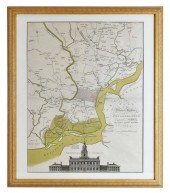 PLAN OF THE CITY OF PHILADELPHIA MAPEngraved
PLAN OF THE CITY OF PHILADELPHIA MAPEngraved and Published by Matthew Albert Lotter, 1777. Showing land plots, the Delaware River and an elevation of the State House (Independence Hall). Image 23.25 by 18 in., overall, matted, framed 28.5 by 24 in.
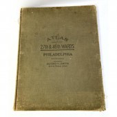 Atlas 27th and 46th wards Philadelphia
Atlas 27th and 46th wards Philadelphia Maps. Colored maps.
Dimensions: H: 22 inches: W: 17 inches: D: 2 inches ---
Condition: See pictures for condition or ask specific questions.
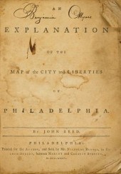 1 vol. Reed, John. An Explanation
1 vol. Reed, John. An Explanation of The Map of The City and Liberties of Philadelphia. Philadelphia: Printed for the Author... sold by... Nicholas Brooks, 1774. 4to, contemp. wrappers; worn and creased, re-backed with old cloth. Some internal dampstaining, scattered light foxing, corners creased. Benjamin Myer's (18th-Century) copy, signed by him at head of title page and front wrapper, also with the 18th-Century signature of John M. George on front wrapper. Issued separately from, but contemporaneously with, Reed's important Philadelphia map. Includes records of the first purchasers in Philadelphia and their lots. Evans 13564 ,200 Descriptions provided in both printed and on-line catalogue formats do not include condition reports. The absence of a condition statement does not imply that the lot is in perfect condition or completely free from wear and tear, imperfections or the effects of aging. Interested bidders are strongly encouraged to request a condition report on any lots upon which they intend to bid, prior to placing a bid. All transactions are governed by Freeman''s Conditions of Sale.
...many more examples with full details are available to our members - Learn more


