A few examples of appraisal values for
GUTHRIES
Search our price guide for your own treasures
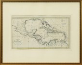 MAP, THE WEST INDIES ACCORDING TO THE
MAP, THE WEST INDIES ACCORDING TO THE BEST AUTHORITIES After William Guthrie (Scottish, 1708-1770), "The West Indies According to the Best Authorities," copper engraved map with hand coloring, published by C. Dilly and G. Robinson, London, 1785, engraved for Guthries New System of Geography, overall (with frame): 23"h x 29.25"w
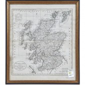 MAP, SCOTLAND WITH THE PRINCIPAL ROADS
MAP, SCOTLAND WITH THE PRINCIPAL ROADS FROM THE BEST AUTHORITIES After William Guthrie (Scottish, 1708-1770), "Scotland with the Principal Roads from the Best Authorities," copper engraved map, published by C. Dilly and G. Robinson, London, 1785, engraved for Guthries New System of Geography, overall (with frame): 18"h x 16"w
 MAP, THE STATE OF VIRGINIA FROM THE
MAP, THE STATE OF VIRGINIA FROM THE BEST AUTHORITIES BY SAMUEL LEWIS 1794, from Carey's American Edition of Guthries Geography improved, copperplate engraving with hand coloring, presented in giltwood frame carrying mid-20th century label from Young's, Richmond, Virginia.
 RUSSELL, JOHN. NORTH AMERICA DRAWN FROM
RUSSELL, JOHN. NORTH AMERICA DRAWN FROM THE BEST AUTHORITIES London, circa 1801 -1811, copperplate engraving with outline color, the upper margin imprinted "Engraved for Guthries New System of Geography," the map itself shows the enormous region between the Caribbean and Alaska's Bering Straight; North America east of the Mississippi River, all of Mexico, and points further south are shown in great detail, whereas the western regions are largely empty all the way to the Pacific; the upper right corner of the back is inscribed in a 20th century hand with "Russell 1801" while number "8" appears in the vicinity as a watermark. The map is in a 1960s wooden frame with a paper backing that should be replaced.
...many more examples with full details are available to our members - Learn more


