 HOUSTON, WE'VE HAD A PROBLEMTranslunar-Transearth
HOUSTON, WE'VE HAD A PROBLEMTranslunar-Transearth Trajectory Plotting Chart, Apollo Mission 13. A multi-colored chart that plots and describes the location
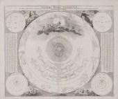 18th Century Celestial Chart German, Systema
18th Century Celestial Chart German, Systema Mundi Tychonicum, by Johann Doppelmayr and Johann Homann, probably from Homann's Atlas Coelestis in quo Mundus
 Translunar-Transearth Trajectory Plotting
Translunar-Transearth Trajectory Plotting Chart, Apollo Mission 13. A multi-colored chart that labels and plots the location of all major flight events
 Earth Orbit Chart (AEO), Apollo Mission 13,
Earth Orbit Chart (AEO), Apollo Mission 13, April 1970. With full 360 degree longitudinal coverage and latitude coverage of +/- 45 degrees. The spacecraft
 Apollo Lunar Flight Chart (ALF), Apollo Mission
Apollo Lunar Flight Chart (ALF), Apollo Mission 15. Plots the range of 74 planned CSM orbital ground tracks around the Moon. June 2, 1971
Signed: "Dave
 FLOWN Apollo 16 Lunar Orbit Chart carried
FLOWN Apollo 16 Lunar Orbit Chart carried to the lunar surface. Consisting of two plates, number 1 and number 24, of the Lunar Orbit Monitor Chart which
 Apollo Lunar Orbit Chart (ALO), Apollo Mission
Apollo Lunar Orbit Chart (ALO), Apollo Mission 16. Plots CSM orbits 1, 39, 41, 60, 62, and 75 with the Descartes landing site ellipse in red. First edition.
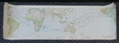
 ASTP Earth Observation Map. A full color
ASTP Earth Observation Map. A full color chart covering almost the entire Earth's surface and featuring the approximately 53 degree orbital inclination
 Fra Mauro Landing Site Chart. A lunar chart
Fra Mauro Landing Site Chart. A lunar chart based on Lunar Orbiter imagery of the Apollo 14 landing site. Approximately 17x22 inches, scale is 1:10,000.
 Target of Opportunity Lunar Orbit Chart (LSC).
Target of Opportunity Lunar Orbit Chart (LSC). Apollo Mission 11, 16 July 1969 Launch Date. A multi-colored chart with full 360 degree longitudinal coverage
 Apollo 10 Translunar - Transearth Trajectory
Apollo 10 Translunar - Transearth Trajectory Plotting Chart. A multi-colored chart that labels and plots the location of all major flight events of the
 Earth Orbit Chart (AEO), Apollo Mission 13,
Earth Orbit Chart (AEO), Apollo Mission 13, April 1970.
Signed and inscribed by Haise: "Fred Haise, Apollo 13 LMP" in the area under the TLI burn plot
 Design Reference Volumes, Mission IIA. Group
Design Reference Volumes, Mission IIA. Group of four documents by the Apollo Mission Planning Task Force that provide a baseline for lunar flight planning.
 Apollo 11 Translunar - Transearth Trajectory
Apollo 11 Translunar - Transearth Trajectory Plotting Chart. Plots the location of all major flight events for the first lunar landing. Events include
 Translunar-Transearth Trajectory Plotting
Translunar-Transearth Trajectory Plotting Chart, Apollo Mission 10. A multi-colored chart that labels and plots the location of all major flight events
 THREE APOLLO 11 MISSION ORBITAL MAP CHARTSThree
THREE APOLLO 11 MISSION ORBITAL MAP CHARTSThree Apollo 11 Mission Orbital Map Charts,


